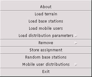
The file menu is mainly used to access data in files, e.g., to load or store data, or to generate random data.

Displays Copyright Information in an acknowledge dialog box.
Loads the terrain data from a file that can be mapped to memory allowing for optimized access of large terrain data. The file name extension must be map. See the terrain map file format for a formal description of the terrain map file content.
The file name is entered through the file select dialog. The selected file name is maintained and will be presented in a subsequent load command as initial dialog value.
A terrain is drawn as a greyish filled rectangle. The corresponding clutter data is drawn as a black rectangle. Note that the building clutter is automatically loaded using the same file name but replacing the extension with urb.
If any of the files cannot be read, an error message is shown. Once a terrain data file has been loaded, it can be removed through the Remove menu entry. Any base stations or mobile users--possibly being loaded previously--are removed.
Loads the base station data from a file. The current base stations are replaced by the new base stations. See the base station file format for a formal description of the base station file content.
The file name is entered through the file select dialog. The selected file name is maintained and will be presented in a subsequent load command as initial dialog value.
Loads the mobile user data from a file. The current mobile users are replaced by the new mobile users. See the mobile user file format for a formal description of the mobile user file content.
The file name is entered through the file select dialog. The selected file name is maintained and will be presented in a subsequent load command as initial dialog value.
Loads the mobile user distribution parameters from a file. The current mobile users are not changed. The new parameters take effect whenever the next mobile user distribution is generated. See the mobile user distribution file format for a formal description of the mobile user distribution file content.
The file name is entered through the file select dialog. The selected file name is maintained and will be presented in a subsequent load command as initial dialog value.
If mobile user distribution parameters are available, the corresponding region for which the parameters are defined is drawn as a yellow rectangle. Once a mobile user distribution parameter file has been loaded, it can be removed through the Remove menu entry.
Stores the complete assignment to a file. The file name is entered through the file select dialog. The selected file name is maintained and will be presented in a subsequent store command as initial dialog value.
Asks for a key value to provide access to all features of the program. This menu might not be present in all demonstration versions.
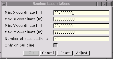
Generates a random distribution of base station locations.

Sets the minimum x-coordinate of the region where the base stations are to be placed randomly. The value is entered in [m].
Sets the maximum x-coordinate of the region where the base stations are to be placed randomly. The value is entered in [m].
Sets the minimum y-coordinate of the region where the base stations are to be placed randomly. The value is entered in [m].
Sets the maximum y-coordinate of the region where the base stations are to be placed randomly. The value is entered in [m].
Sets the number of base stations to be generated in the random distribution. The value must be greater than one.
Selects whether the base stations should be generated only on top of building blocks or whether they can be located in free areas as well. The option is only available when terrain data are loaded.
Note that until the height of the base station antenna has not been changed through the base station dialog the height during simulation is set to the values specified in the heights settings.
The [Adjust] button automatically adjusts the coordinates of the region to the underlying terrain data. The button is only available when terrain data are loaded.
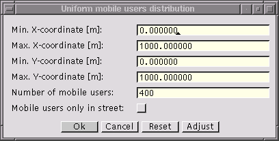
Generates a random distribution of mobile user locations.

Sets the minimum x-coordinate of the region where the mobile users are to be placed randomly. The value is entered in [m].
Sets the maximum x-coordinate of the region where the mobile users are to be placed randomly. The value is entered in [m].
Sets the minimum y-coordinate of the region where the mobile users are to be placed randomly. The value is entered in [m].
Sets the maximum y-coordinate of the region where the mobile users are to be placed randomly. The value is entered in [m].
Sets the number of mobile users to be generated in the random distribution. The value must be greater than zero.
Selects whether the mobile users should be generated only within street or whether they can be located inside of buildings as well. The option is only available when terrain data are loaded.
The [Adjust] button automatically adjusts the coordinates of the region to the underlying terrain data. The option is only available when terrain data are loaded.

Sets the percentage of mobile users that should be activated during the generation of mobile users and according to the distribution parameters.
Selects whether the mobile users should be generated only within street or whether they can be located inside of buildings as well.
Exits optimUMTS immediately.